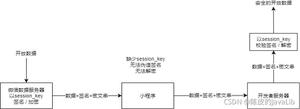
微信小程序地图实现展示线路
本文实例为大家分享了微信小程序地图实现展示线路的具体代码,供大家参考,具体内容如下
效果图:
思路:
1、首先获取一系列的坐标点,然后将这些坐标从头到尾链接起来。(参考微信小程序地图组件polyline属性)
2、在获取的坐标点上标注某一个位置,实现打点。(参考微信小程序地图组件marker属性 )
3、使用map组件
微信小程序地图组件api地址
下面直接展示代码:
wxml:
<view class="page-section page-section-gap">
<!-- longitude="{{longitude}}" latitude="{{latitude}}" scale="16" height: {{view.Height}}px;show-location-->
<map class="navi_map" include-points='{{points}}' longitude="{{longitude}}" latitude="{{latitude}}" polyline="{{polyline}}" markers="{{markers}}" bindcallouttap="bindcallouttap" bindmarkertap="markertap" style="width: 100%; height: {{view.Height}}px;" wx:if="{{hasMarkers}}" scale="10" ></map>
</view>
<view class="maptext" wx:if="{{mapList!=''}}">
<view class="news">
<view wx:if="{{mapList.polylineJson!=null}}">预计<text style="color:#FF6565">{{now}}</text>送达</view>
<view class="tishi">由药店提供配送服务</view>
</view>
<view class="phone_box">
<view style="" class="right_box" data-phone="{{mapPhone}}" bindtap="makeCallPhone" wx:if="{{mapPhone!=null}}">
<image src="{{imgUrl}}mapshop_phone.png"></image><view style="line-height:96rpx">联系商家</view>
</view>
<view class="left_box" data-deliverhone="{{deliverPhone}}" bindtap="makesCallPhone" wx:if="{{deliverPhone!=null}}">
<image src="{{imgUrl}}map_phone.png"></image><view style="line-height:96rpx">联系配送员</view>
</view>
</view>
</view>
js:
data: {
longitude: '',
latitude:'',
points: [],
polyline: [],
markers: [],
mapList:'',
polylineList:[],
},
mapLine(options){
wx.showLoading({
title: '加载中',
})
let subOrderNo = options.maporder
console.log(subOrderNo)
let that=this
let token = that.data.storageData.token
let url = '接口地址';
let params = {
subOrderNo:subOrderNo
};
http.getRequest(url, params, token).then(res => {
// 地图打点标记商家和配送员位置
let markers= [
{
iconPath: imgUrl+'shoplong.png',
id: 0,
latitude: that.data.mapList.pharmacyInfo.latitude,
longitude: that.data.mapList.pharmacyInfo.longitude,
callout: {
content: that.data.mapList.pharmacyInfo.pharmacyName+"已接单",
name:"商家已接单",
color: "#ff0000",
fontSize: "16",
borderRadius: "6",
bgColor: "#ffffff",
padding: "10",
display:"ALWAYS"
},
width: 50,
height: 50
},
{
iconPath:imgUrl+ 'maplog.png',
id: 1,
latitude: that.data.mapList.locationList[0].latitude,
longitude: that.data.mapList.locationList[0].longitude,
callout: {
content: "配送员正在配送",
name:"正在配送",
color: "#ff0000",
fontSize: "16",
borderRadius: "6",
bgColor: "#ffffff",
padding: "10",
display:"ALWAYS"
},
width: 50,
height: 50
},
];
console.log(markers)
let _this=this
_this.setData({
markers:markers,
hasMarkers:true,
latitude:that.data.mapList.pharmacyInfo.latitude,
longitude:that.data.mapList.pharmacyInfo.longitude
})
if(orderDeliver.polylineJson!=null){
let mapJson = JSON.parse(orderDeliver.polylineJson);
console.log(mapJson)
// 计算送达时间
let mapDate=that.data.mapList.updateTime
let newsDate=new Date(mapDate)
// let h = newsDate.getHours()
let m = newsDate.getMinutes()
let mapMinte=mapJson.route.paths[0].duration/60
newsDate.setMinutes(m+mapMinte)
let dd=newsDate.getMinutes()
let hh=newsDate.getHours()
if(dd<10){
dd='0'+dd
}
if(hh<10){
hh='0'+hh
}
let now=hh +':'+dd;
if(newsDate.getMinutes()>=60){
h=h+1;
}else{
this.setData({
now:now
})
console.log(now)
}
// 循环数组取快递员的经纬度
let list = mapJson.route.paths[0].steps;
// console.log(list);
let polylineList = [];
for(let i =0;i<list.length;i++){
let polyline = list[i].polyline;
if(polyline.indexOf(";") != -1){
let pList = polyline.split(";");
// console.log(pList)
pList.map((items,index) =>{
let a = items.split(",");
polylineList.push({
latitude: a[1],
longitude: a[0]
});
// console.log(polylineList)
})
// polylineList.concat(pList);
}
}
let polyline = [{
points: polylineList,
color: "#518FF8",
width: 4,
dottedLine: false
}];
this.setData({
polyline:polyline,
points:polylineList,
})
}
}else if(res.responseCode == 0 && res.responseBody != null && res.responseBody.length != 0 && res.responseBody.deliverType ==2){
let list_di=res.responseBody.deliverType
let maplistJson=res.responseBody.polylineJson
let listMap=JSON.parse(maplistJson)
console.log(listMap)
let logList=listMap.data.reverse()
logList.forEach(element => {
element.ftime = element.ftime.substring(0,16)
});
console.log(logList)
this.setData({
mapList:[],
hasMarkers:false,
logList:logList,
list_di:list_di
})
// sysMsg.sysMsg("商家还未接单,请稍后查看", 2000, 'none');
}else{
sysMsg.sysMsg("商家还未接单,请稍后查看", 2000, 'none');
}
}).catch(err => {
console.log(err);
sysMsg.sysMsg("请求超时,请稍后再试", 1500, 'none');
})
},
onLoad: function (options) {
this.mapLine(options)
this.mapHeight()
this.mapLog()
// this.markers()
// console.log(options.maporder)
this.getstorageDataToPage()
// qq地图api
qqmapsdk = new QQMapWX({
key: '申请的微信小程序地图key'
});
},
为大家推荐现在关注度比较高的微信小程序教程一篇:《微信小程序开发教程》小编为大家精心整理的,希望喜欢。
以上是 微信小程序地图实现展示线路 的全部内容, 来源链接: utcz.com/z/335916.html