如何根据离散的数据点获取线性的线段?
[ [
{
"id": 444810098964868900,
"distance": 0.20106235146522522,
"score": 0.20106235146522522,
"video_uuid": "夏洛特烦恼原片-5min",
"pts": 0,
"timeline": 0
}
],
[
{
"id": 444810098964868900,
"distance": 0.19771885871887207,
"score": 0.19771885871887207,
"video_uuid": "夏洛特烦恼原片-5min",
"pts": 0,
"timeline": 0
}
],
[
{
"id": 444810098964868900,
"distance": 0.17275215685367584,
"score": 0.17275215685367584,
"video_uuid": "夏洛特烦恼原片-5min",
"pts": 0,
"timeline": 0
}
],
[
{
"id": 444810098964868900,
"distance": 0.20370642840862274,
"score": 0.20370642840862274,
"video_uuid": "夏洛特烦恼原片-5min",
"pts": 0,
"timeline": 0
}
]
]
使用 python 把上面的 json 转成点图,把 json 是 list[list[dict]] 的,把 dict 里面的 pts 作为纵坐标,把 list 的 index 作为横坐标
然后我写了下面的代码
from mark import BASE_DIRimport json
# with
import json
import matplotlib.pyplot as plt
with open(BASE_DIR/'dev/graph/raw.json', 'r', encoding='utf-8') as file:
data = json.loads(file.read())
# 提取pts值
pts_values = [entry[0]["pts"] if entry else 0 for entry in data]
# 创建横坐标(使用列表的索引)
x_values = list(range(len(data)))
# 创建点图
plt.scatter(x_values, pts_values, marker='o', color='b', label='Pts Values')
# 添加标题和标签
plt.title('Pts Values vs. Index')
plt.xlabel('Index')
plt.ylabel('Pts Value')
# 显示图表
plt.legend()
plt.grid(True)
plt.show()
渲染出来的图如下
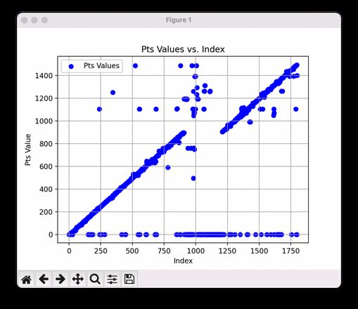
对于上面的图,我希望可以输出 [0,900]->[0,900] 和 [900,1550]->[1200,1550]
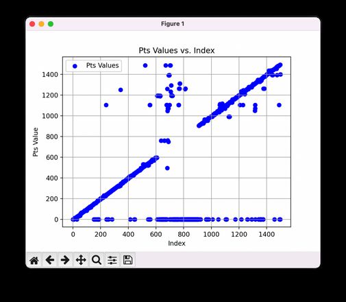
对于上面的图,我希望可以输出 [0,900]->[0,900] 和 [1200,1550]->[1200,1550]
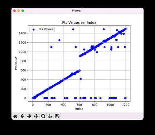
对于上面的图,我希望可以输出 [0,600]->[0,600] 和 [600,1200]->[900,1500]
也就是统计图像中有一共个多少个线段,并且输出这些线段的起点坐标到终点坐标
难点在于,这些线段不一定是强连续的,可能中间会断开一个点,这些不规则的点可能会变成干扰因素
我想的是怎么统计出所有线段,并且可以排除因为一些点没有在线段上导致的干扰
忽略纵坐标为 0 的点,不纳入统计
回答:
用js实现了下,思路应该是相通的
// 在一条直线上的点都满足 y = ax + bvar array = [0, 1, 2, 3, 4, 5, 6, 0, 10, 11, 12, 13, 14, 15]
var slopes = []
async function main() {
for (let i = 0; i < array.length; i++) {
for (let j = i + 1; j < array.length; j++) {
if (i != j) {
var a = (array[j] - array[i]) / (j - i)
var b = array[i] - a * i
var cur = slopes.find(item => item.a == a && item.b == b)
if (cur) {
cur.flag++
} else {
slopes.push({ a, b, flag: 1, points: [] })
}
}
}
}
slopes = slopes.sort((cur, pre) => pre.flag - cur.flag)
slopes = slopes.filter(item => item.flag > 5)
for (const line of slopes) {
var a = line.a
var b = line.b
for (let i = 0; i < array.length; i++) {
if (array[i] == a * i + b) {
line.points.push({ x: i, y: array[i] })
}
}
line.length = line.points.length
}
console.log(JSON.stringify(slopes, null, 2))
}
main()
回答:
绘图之前进行数据预处理,排除掉干扰数据,这样绘图会不会好点
回答:
了解了一下,有以下现成的算法可以使用:
传统的:
- 霍夫变换
- Canny 边缘检测算法
- EDlines直线检测算法
- 直线段检测算法LSD
基于深度学习的:
- LCNN
- TP-LSD
以上是 如何根据离散的数据点获取线性的线段? 的全部内容, 来源链接: utcz.com/p/939044.html


